


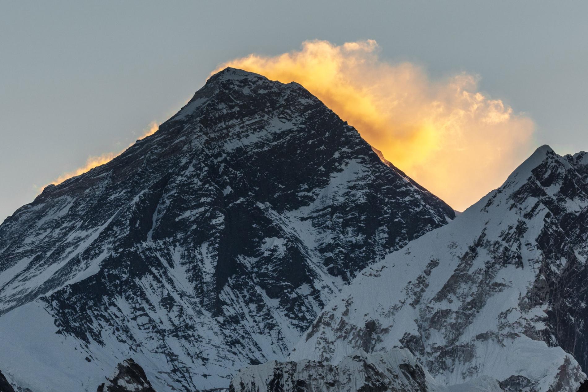
Everest Keep changing its height


The highest point on Earth has a newly announced elevation. Mount Everest is 29,031.69 feet above sea level, according to survey results presented today. That is more than two feet higher than the altitude previously recognized by the government of Nepal.
The elevation, which was announced on December 8 in a joint statement by the Survey Department of Nepal and Chinese authorities, is the culmination of a multiyear project to definitively measure the legendary mountain. As the first serious survey of Everest in 16 years, the effort has been closely followed by the geographic community—particularly scientists analyzing how a devastating 7.8 magnitude earthquake in 2015 affected the region.
Last spring a small group of Nepalese surveyors and guides endured the biting cold of a nighttime ascent, reaching the top at 3 a.m. local time so they could conduct their work unimpeded by crowds of recreational climbers, to try to settle the matter.
“We want to deliver the message that we can do something with our own [country’s] resources and technical manpower,” Khimlal Gautam, chief survey officer for the project, told National Geographic last year.
Technological peaks
In 1856, mathematician Radhanath Sickdhar found that Everest is the highest mountain in the world while he was working for the Great Trigonometrical Survey, a project dedicated to surveying and mapping the Indian subcontinent. Since then, a handful of surveys have sought to pin down the mountain’s true height with the best technology available at the time.
Until the advent of satellites, surveyors used a device called a theodolite, a precision optical instrument mounted on a tripod, for measuring angles between two designated points. Lugging their heavy equipment from hilltop to hilltop, a survey team would incrementally measure Everest’s height from sea level, zig-zagging north from the Bay of Bengal until they could see the peak.
A 1954 survey using a similar technique calculated that Everest stands at 29,028 feet above sea level, a number that is still recognized by many countries and map publishers.


Then in 1999 a survey led by cartographer and explorer Bradford Washburn, and sponsored by the National Geographic Society, was the first to use GPS technology to measure the Everest summit. That team’s work delivered an altitude of 29,035—the figure still in use by the Society until the new measurements can be fully verified.
Mounting excitement
To make their new survey as complete as possible, the Nepalese team decided to employ both techniques. On May 22, 2019, Gautam summited Everest with four teammates and deployed a GPS receiver, along with ground-penetrating radar to measure the depth of the snow piled on top of the rock. Meanwhile, teams of surveyors waited at eight sites with views of Everest’s summit to fix its elevation at sunrise, when the atmosphere is most clear, with modern laser theodolites.
But after the Survey Department of Nepal completed its field work last year, the project became mired in international politics. During Chinese President Xi Jinping’s state visit to Nepal in October 2019, officials announced that the two countries would cooperate in re-surveying the mountain, delaying the revelation of the new height. A team of Chinese surveyors were at work on the north side of the mountain this spring measuring the summit using China’s network of Beidou satellites, a rival to the GPS system.
Now that the results have been announced, representatives from both countries expressed extreme confidence in the new altitudes. But Gautam is quick to point out that no matter how accurate, every survey comes with some margin for error. “In survey mapping, we can’t find the exact point or altitude,” he says. “We’re trying to find the MPV: most probable value.
Source: National Geographic

به اطلاع آن دسته از متقاضیان مدرک مربی راهنمای سطح باشگاهها می رساند مدارک صادر شده افرادی که تا کنون جهت دریافت به فدراسیون مراجعه نکرده اند به هیئت کوهنوردی و صعودهای ورزشی استان تحویل گردید....
با توجه به بررسی و اعلام کمیته آموزش فدراسیون، با توجه به بارشهای اخیر و مناسب بودن شرایط جوی، به اطلاع میرساند؛ برگزاری دوره آموزشی نجات در برف در استانهای کردستان، اصفهان، چهارمحال و بختیاری، لرستان، تهران، فارس و همدان بلامانع میباشد...

به اطلاع کلیه مربیان و مدرسان میرساند؛ فعالیت خود و کلاسهای آموزشی اعم از عملی و تئوری را جهت برگزاری کلاس میبایست طبق موارد زیر اقدام نمایند: ...

با توجه به نیازهای آموزشی، الزامات اجرای برنامههای دره نوردی به ویژه برنامههایی که درگیر با جریان های آبی می باشند را به شرح زیر به اطلاع میرساند؛
صندوق اعتباری حمایت از قهرمانان و پیشکسوتان ورزش کشور در راستای بند (ب) ماده (۷۸) قانون برنامه هفتم پیشرفت و پیرو توافقنامه با سازمان تأمین اجتماعی، فهرست بیمهشدگان مدالآوران ورزش برای مهر و آبان ماه سال جاری را ارسال کرده است. در این راستا، از قهرمانان و مدالآوران درخواست شده است که جهت بهرهمندی از مزایای بیمه اجتماعی، اقدام به عضویت در صندوق حمایت از قهرمانان نمایند.

با توجه به برگزاری دوره مربیگری درجه 3 کوهپیمایی مورخ 9 الی 13 آذرماه 1404 در استان ایلام، اسامی قبول شدگان دوره فوق به شرح زیر اعلام می گردد:...
مراسم وداع و خاکسپاری زندهیاد «کیومرث بابازاده»
بررسی دعوت از مربی خارجی و برنامهریزی اردوهای تیم ملی در جلسه هیئترئیسه فدراسیون کوهنوردی و صعودهای ورزشی
تسلیت به جناب آقای «جواد اکبری» از همکاران کمیته پناهگاههای فدراسیون و مسئول بارگاه سوم دماوند
پيش بيني جوي مناطق كوهستاني كشور طي پنجشنبه و جمعه( ١٦ و ١٧ بهمن ماه ١٤٠٤)
تسلیت فقدان تأثرانگیز پیشکسوت ارجمند کوهنوردی جناب آقای «کیومرث بابازاده»
هشدار شرایط نامساعد جوی در روزهای 14 تا 17 بهمن ماه 1404 و احتمال وقوع بهمن
تحویل احکام راهنمایان کوهستان استان «اصفهان»
دستورالعمل امداد و نجات کوهستان در ارتفاعات شمالی کلانشهر تهران تدوین میشود
دهه فجر انقلاب اسلامی مبارک
🔴هشدار وقوع كولاك، سرمازدگي جدي و پتانسيل بالاي وقوع بهمن
تحویل احکام راهنمایان کوهستان استان «اصفهان»
اطلاعیه کمیته آموزش درخصوص برگزاری دوره آموزشی نجات در برف
الزامات مربیان و مدرسان در ساختار آموزشی پرتال فدراسیون
اطلاعیه / توصیههای اجرای برنامههای درهنوردی و جریان های آبی
درخواست اقدام فوری قهرمانان برای عضویت در صندوق بیمه اجتماعی
اعلام نتایج دوره مربیگری درجه سه کوهپیمایی استان ایلام
اسامی پذیرفتهشدگان هفتمین دوره بازآموزی سراسری طراحان صعودهای ورزشی آبان 1404 – اصفهان
تغییر محل برگزاری دوره بازآموزی مربیگری درجه ۳ کوهنوردی با اسکی
اعلام شرایط محیا کردن رزومه و ثبتنام در آزمونهای ورودی مربیگری درجه ۳ و ۲ برف و یخ - سال ۱۴۰۵
اردوی انتخابی تیم ملی پاراسنگنوردی گرایش سرطناب / رده سنی آزاد ـ بهمن 1404
مراسم وداع و خاکسپاری زندهیاد «کیومرث بابازاده»
بررسی دعوت از مربی خارجی و برنامهریزی اردوهای تیم ملی در جلسه هیئترئیسه فدراسیون کوهنوردی و صعودهای ورزشی
تسلیت به جناب آقای «جواد اکبری» از همکاران کمیته پناهگاههای فدراسیون و مسئول بارگاه سوم دماوند
پيش بيني جوي مناطق كوهستاني كشور طي پنجشنبه و جمعه( ١٦ و ١٧ بهمن ماه ١٤٠٤)
تسلیت فقدان تأثرانگیز پیشکسوت ارجمند کوهنوردی جناب آقای «کیومرث بابازاده»
هشدار شرایط نامساعد جوی در روزهای 14 تا 17 بهمن ماه 1404 و احتمال وقوع بهمن
تحویل احکام راهنمایان کوهستان استان «اصفهان»
دستورالعمل امداد و نجات کوهستان در ارتفاعات شمالی کلانشهر تهران تدوین میشود
دهه فجر انقلاب اسلامی مبارک
🔴هشدار وقوع كولاك، سرمازدگي جدي و پتانسيل بالاي وقوع بهمن
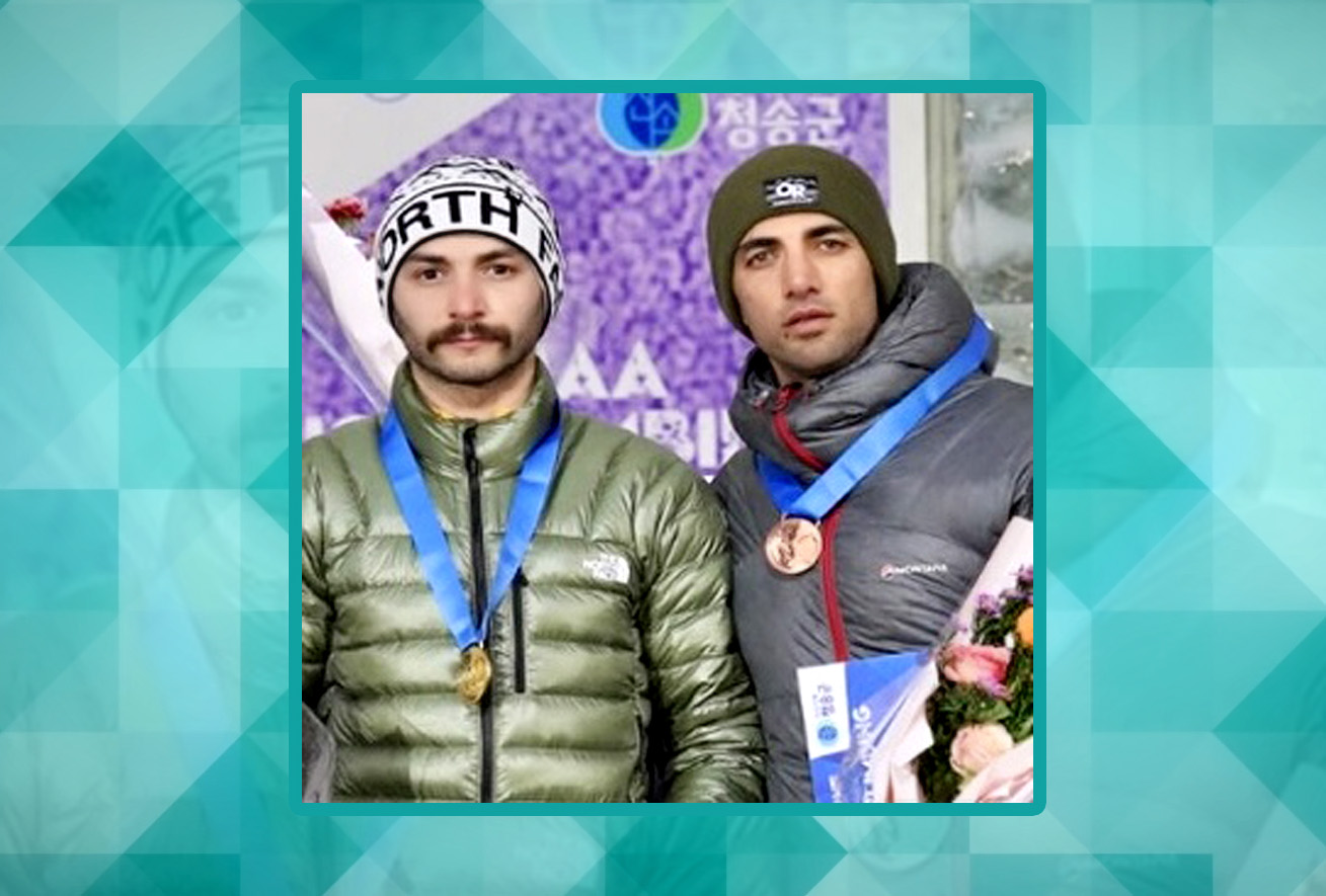
درخشش مجدد یخنوردان ایران در جام جهانی سوئیس؛ «صفدریان» قهرمان شد، «بهشتی» نایبقهرمان
انتخاب دو یخنورد عنواندار ایرانی به عنوان نفرات برگزیده جهت صعود نمایشی برای المپیک زمستانی آینده
پیام تبریک وزارت ورزش و جوانان پس از نشانهای طلا و برنز جامجهانی یخنوردی
کسب مدالهای طلا و برنز یخنوردان کشورمان در جام جهانی


برگزاری نشست کمیسیون طراحی فدراسیون جهانی صعودهای ورزشی
برگزاری نشست کمیسیون رسانه و بازاریابی فدراسیون جهانی صعودهای ورزشی با طرح «ساختن جامعه جهانی صعودهای ورزشی»
نشست کمیسیون حکمرانی فدراسیون جهانی صعودهای ورزشی با محوریت اصلاحات ساختاری و حقوقی
انعقاد تفاهمنامه میان فدراسیونهای کوهنوردی ایران و افغانستان
درخشش مجدد یخنوردان ایران در جام جهانی سوئیس؛ «صفدریان» قهرمان شد، «بهشتی» نایبقهرمان
انتخاب دو یخنورد عنواندار ایرانی به عنوان نفرات برگزیده جهت صعود نمایشی برای المپیک زمستانی آینده
پیام تبریک وزارت ورزش و جوانان پس از نشانهای طلا و برنز جامجهانی یخنوردی
کسب مدالهای طلا و برنز یخنوردان کشورمان در جام جهانی
برگزاری نشست کمیسیون طراحی فدراسیون جهانی صعودهای ورزشی
برگزاری نشست کمیسیون رسانه و بازاریابی فدراسیون جهانی صعودهای ورزشی با طرح «ساختن جامعه جهانی صعودهای ورزشی»
نشست کمیسیون حکمرانی فدراسیون جهانی صعودهای ورزشی با محوریت اصلاحات ساختاری و حقوقی
انعقاد تفاهمنامه میان فدراسیونهای کوهنوردی ایران و افغانستان